The Trout Loop
A Toms Creek & Southern Michaux Greenway Project.
Connecting
Trails
History
Join Us
April 1st
...MORE INFO


Communities
Take Our Community
Survey


Our Goals
The Trout Loop Project is a proposed greenway and trail network that connects communities, recreation areas, and historic sites, protects critical trout habitat, encourages sustainable resource stewardship, and promotes place-based economic development.


Following the Water
Toms Creek is a 20.8-mile long tributary of the Monocacy River located in Pennsylvania and Maryland. The greenway project area encompasses the upper portion of the watershed, located in southwestern Adams County and southeastern Franklin County, an area of approximately 15 square miles.
Upper Toms Creek is rated as a “High Value” stream by the Commonwealth of Pennsylvania, with an application under review to raise the status to “Exceptional Value.”
Recreational lands and trails are located along its corridor including Michaux State Forest and the Appalachian Trail, and the watershed serves as a source water protection area and aquifer recharge area for downstream communities. The upper Toms Creek watershed is also listed as a priority conservation watershed by the Pennsylvania Natural Heritage Program and is identified as a special protection watershed by the Southwest Adams County Joint Comprehensive Plan.


Macro Invertebrate Count
Saturday, April 1st - 12:30 pm
Strawberry Hill Nature Preserve
Hi Toms Creekers - It has been a few years since our last in person gathering - for any purpose! But Friends of Toms Creek is alive and well and has been busy! One month from today - Saturday, April 1st - we will count macro invertebrates (water critters) from Toms Creek. This was done twice yearly for many years but we took a break on the citizen science effort during Covid and had the count done by a professional in the interim. "Macros" can be seen by the naked and eye and are excellent indicators of the health of a stream.
We are asking for volunteers to help with the count this year. All you need are good eyes (or good glasses), willing hands and the ability to match the critters to charts that are provided. All the samples and equipment will be provided courtesy of Watershed Alliance of Adams County. We are happy to welcome children as well - supervised by an adult.
If you could please RSVP, we would like to get a headcount on volunteer numbers! Many thanks and look forward to seeing you at Strawberry Hill Nature Preserve on April 1st at 12:30!

Preserving History
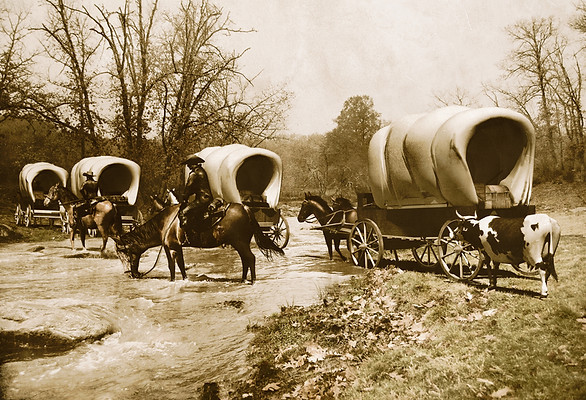
The Toms Creek watershed, in southcentral Pennsylvania, has witnessed many events that helped shape the nation. It was the site of the Great Wagon Road, constructed in the mid-1700s to connect Philadelphia to frontier lands in Virginia, North Carolina and eventually Georgia, providing passage west for early settlers.
What began as a hunting trail used by Native Americans, expanded into one of the most widely used colonial highways in the nation. It was the route of General Lee’s retreat from Gettysburg in July 1863, and Nichols Pass, near the creek’s headwaters, was the site of Pennsylvania’s second largest Civil War Calvary battle that occurred during the Confederates’ retreat. It is the location of early mills and an iron foundry constructed by Thaddeus Stevens.